Cape Fear River · Brunswick County, North Carolina
A working shore, read backward
From an 1840s railroad yard to a guano warehouse the size of a city block, a naval-stores row, and a graveyard of abandoned hulls, Eagles Island quietly supported Wilmington's industrial economy for more than a century. This map, photographic record, and timeline document that history through archival photographs, maps, archaeological evidence, and the research of Sami Kay Seeb and Robert J. Minford.
1730s – 2026Span of documented use
4Core historical themes mapped
37+Vessels in the ships' graveyard
Scroll to explore ↓
Research foundation
Built on the work of Sami Kay Seeb and Robert J. Minford
This project is deeply indebted to two East Carolina University master’s theses that established the essential documentary framework for understanding Eagles Island. Their research provides much of the foundation for the map, timeline, and interpretation presented here.
2007 · East Carolina University
Sami Kay Seeb
Cape Fear’s Forgotten Fleet: The Eagles Island Ships’ Graveyard, Wilmington, North Carolina
Seeb documented the island’s abandoned vessels, marine railways, shipyards, and maritime archaeological sites. Her thesis remains the principal research source for the Eagles Island ships’ graveyard and its industrial shoreline.
For the Love of Profit: Examining Traditional Capitalism on Eagles Island, North Carolina
Minford traced the island’s broader economic history, including rice plantations, naval stores, cotton facilities, transportation, shipbuilding, land use, and the succession of businesses that operated there.
The site supplements their scholarship with archival maps, museum and library collections, archaeological reports, contemporary newspaper accounts, and more recent field research. Interpretive errors remain the responsibility of this project, not the thesis authors.
Where the story happened
Eagles Island between two rivers
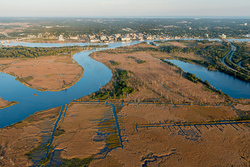
Eagles Island lies directly across the Cape Fear River from downtown Wilmington, bounded on the west by the Brunswick River. Its position connected rice fields and inland transportation routes with Wilmington’s working waterfront.
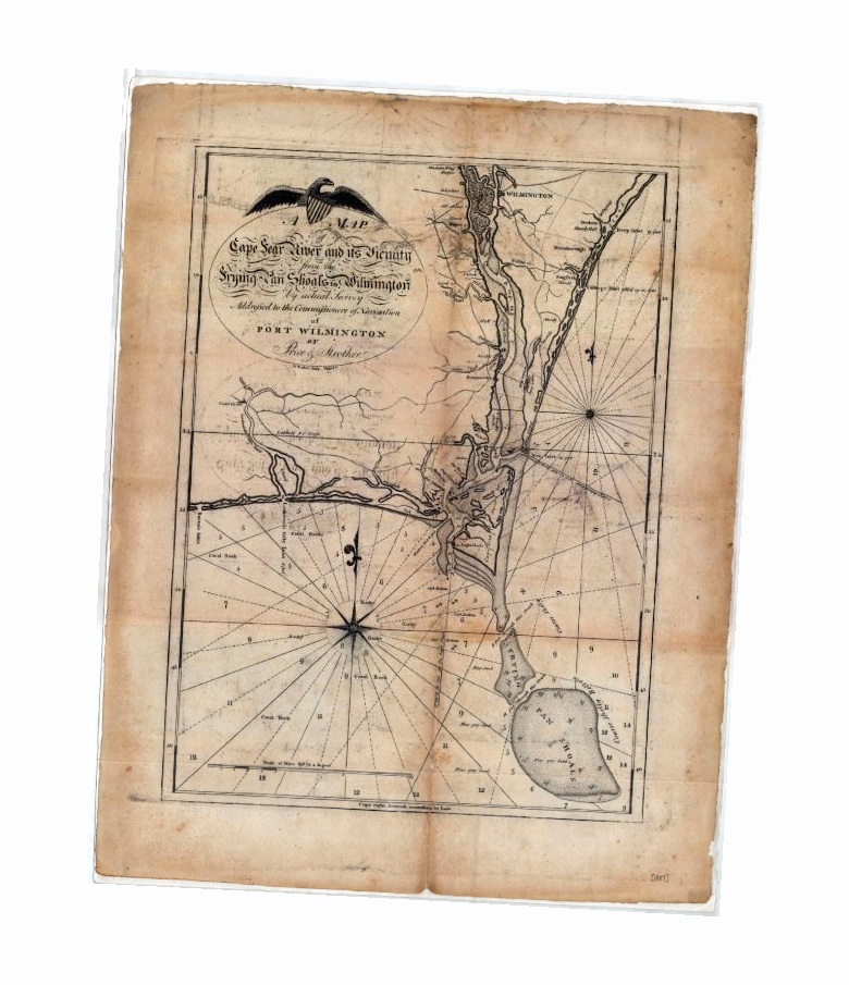
How to read the maps: the locator establishes the island’s present-day geography. The 1798 chart shows how an early surveyor understood the Cape Fear River system, but its shoreline and channel positions should not be transferred directly onto a modern map.
A road joined by two ferries
Across two rivers
For generations, travel between Wilmington and Brunswick County was a three-part journey: a ferry across the Cape Fear River, the causeway across Eagles Island, and a second ferry—or later a bridge—across the Brunswick River. The route made the island a transportation corridor long before it became an industrial waterfront.
1Cape Fear ferryWilmington to Eagles Island
2Island causewayAcross wet ground and creeks
3Brunswick crossingFerry, then bridge after 1890
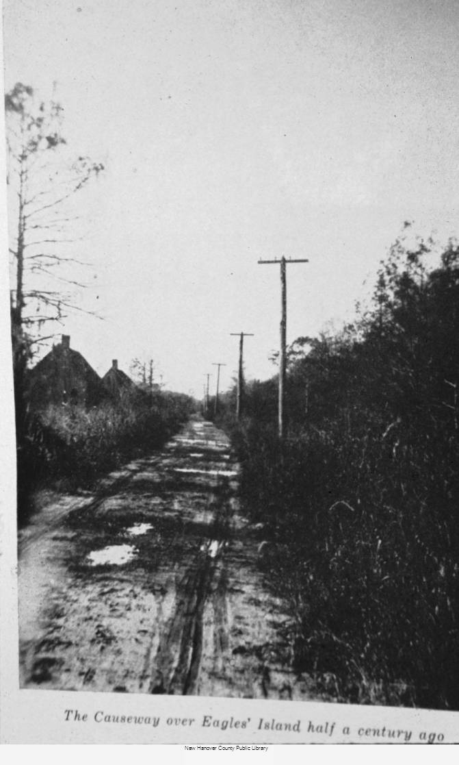
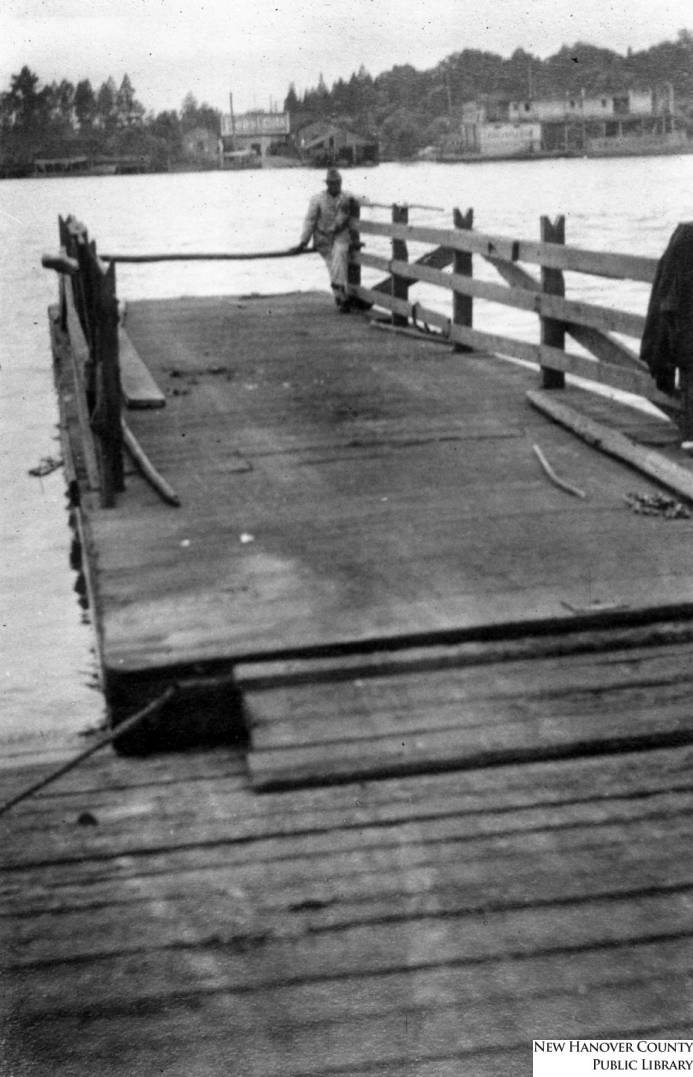
The Eagles Island causeway, looking west. The narrow road remained vulnerable to mud, flooding, and deterioration well into the modern period. Courtesy of the Dr. Robert M. Fales Collection, New Hanover County Public Library; reproduced in Minford, fig. 4-5.The Market Street ferry slip. Passengers, livestock, wagons, and later automobiles entered the ferry here for the short crossing to Eagles Island. Courtesy of New Hanover County Public Library.
Building a road through a tidal landscape
Colonial authorities commissioned Col. William Dry to build a road across Eagles Island in 1764. After Dry’s death, his son-in-law Benjamin Smith completed the causeway in 1791. Minford reports that approximately 200 enslaved people performed most of the labor. The road was about 16 feet wide and two feet above high water, built from logs, ballast stone, sand, clay, and earth, with small wooden bridges over island creeks.
The two-ferry journey
Darby Eagan was operating the Cape Fear crossing by 1769. Travelers reached Eagles Island on a flatboat, crossed the causeway, and boarded the Brunswick River ferry. Postal surveyor Hugh Finlay found the log road badly broken in 1774; difficult ground and irregular maintenance remained persistent problems.
Company control and gradual modernization
The Brunswick Bridge and Ferry Company was incorporated in 1873 to operate the ferries, maintain the causeway, build toll bridges, and collect tolls. A permanent Brunswick River bridge opened in 1890, eliminating the western ferry leg. After a 1900 fire, the company rebuilt waiting rooms and stables, added safer roofs and an electric call bell, and replaced the oar-powered arrangement with gasoline propulsion in 1907.
Public ownership and automobile ferries
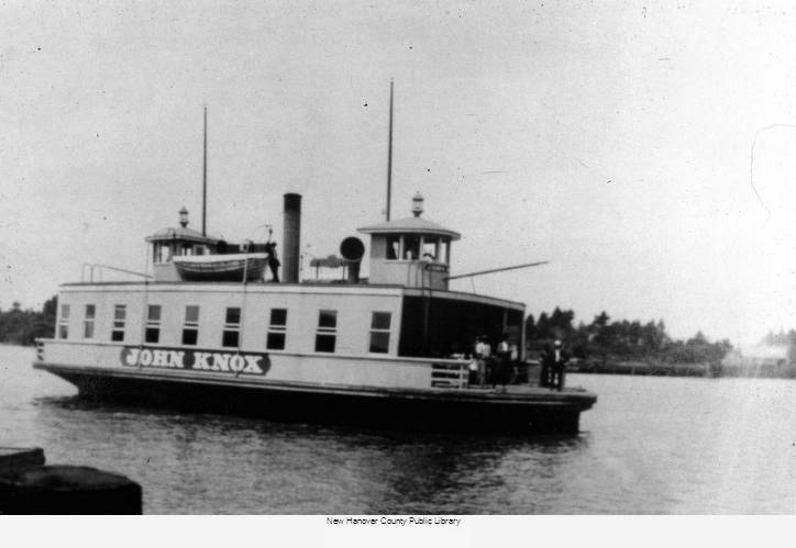
New Hanover and Brunswick counties purchased the company on October 1, 1919. The steam-powered John Knox entered service in 1920, followed by Menantic in 1924. The larger vessels transformed an old local crossing into an important automobile route.
Bridges arrive—but the ferry continues
The Twin Bridges opened north of downtown on December 10, 1929, crossing the Northeast Cape Fear River to Point Peter and then the Cape Fear River toward Eagles Island. Because the bridges initially charged tolls, the counties continued reduced ferry service. When the bridge tolls ended, John Knox made the final Market Street crossing at 1:15 p.m. on February 6, 1935.
A transportation route becomes archaeology
John Knox sank near the former landing in 1937; its remains are archaeological site 0016CFR. The Cape Fear Memorial Bridge opened in 1969, and a new Brunswick River bridge and bypass followed in 1977, leaving the old causeway as a surviving fragment of the island’s transportation landscape.
The canals and embankments crossing Eagles Island are not simply drainage features. They are the surviving framework of a rice landscape created through African knowledge, forced labor, and generations of adaptation before and after emancipation.
Tidal rice cultivation depended upon controlling when river water entered and left each field. Enslaved workers cleared wetlands, raised banks, cut canals and ditches, and built and maintained gates and other wooden water-control structures. The resulting system could flood fields and drain them again as the crop required.
West and Central Africans brought experience with rice cultivation and wetland environments to the Americas. Enslavers exploited that knowledge as well as their labor. The wealth produced by rice therefore rested on both specialized African expertise and a system of coercion.
01
Labor and human cost
Rice work was physically punishing and was performed in wet, mosquito-filled environments. Across the coastal rice region, enslaved people planted, weeded, flooded, drained, harvested, threshed, and processed the crop. The regional “task system” assigned a defined amount of work, but it remained forced labor enforced by violence and the power of enslavers.
02
Plantations on Eagles Island
Minford’s research identifies three island plantations in the second half of the nineteenth century: Hallett, Bleak House, and Osawatomie. Their precise boundaries remain uncertain. Other rice holdings crossed the Brunswick River or formed parts of larger properties, including Belleville Plantation and land acquired by the Navassa Guano Company.
03
After emancipation
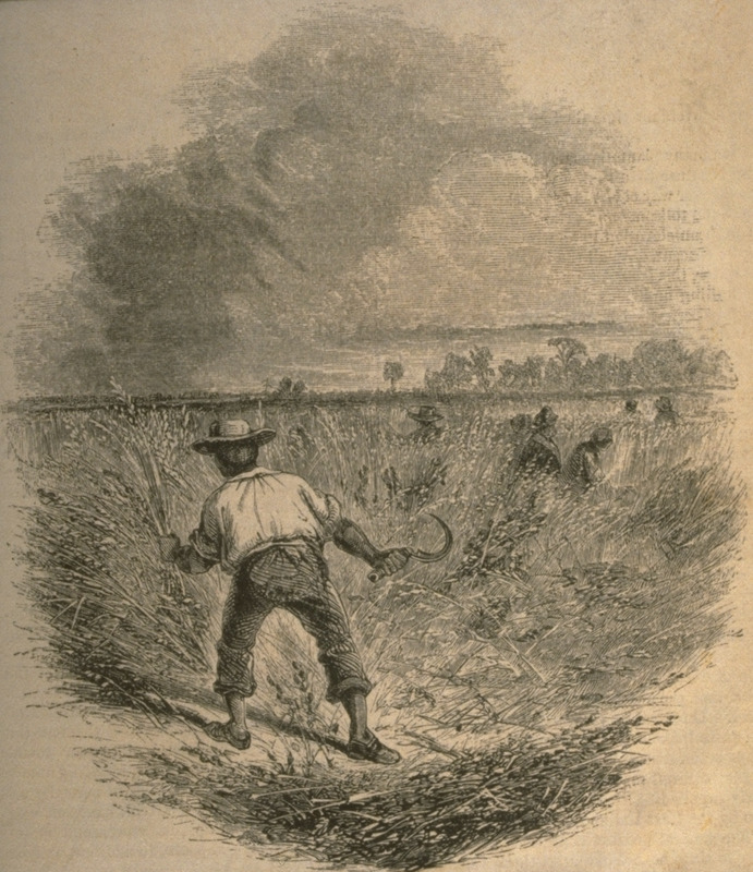
Emancipation ended legal slavery, not exploitation. Hallett continued operating for roughly two decades after the Civil War. Black farmers leased part of Daniel L. Russell’s Eagles Island land in the 1890s. In 1902, the Cape Fear Rice Company leased Bleak House and Osawatomie and used incarcerated laborers to harvest rice.
04
Survival and inheritance
Gullah Geechee heritage encompasses far more than agricultural labor. Language, foodways, spirituality, crafts, family life, and community traditions carried African knowledge forward under enslavement and afterward. On Eagles Island, the clearest surviving local evidence is the engineered landscape itself.
Northern thirdsurvey area designated the Eagles Island Rice District
2 yearsof field observation and shallow-water sonar survey
The archaeological survey
Reading the rice fields from the water
Mark U. Wilde-Ramsing and Joni Thomas “Osku” Backstrom concentrated on the northern third of Eagles Island, where much of the historic field-and-canal pattern remains intact. They designated this study area the Eagles Island Rice District. It was a focused investigation of the surviving rice landscape—not a systematic survey of the island’s entire 6,000 acres or of the industrial waterfront near the Battleship.
Where they looked
The team followed shallow canals and waterways within the northern rice fields and examined exposed features along their banks and entrances. These confined, tidal passages preserve the remains of the system that once moved water through the fields.
How they worked
They combined visual inspection from kayaks and other non-motorized vessels with a customized side-scan sonar system designed for very shallow water. Low-tide observations recorded exposed timbers; sonar revealed structures obscured by dark, sediment-filled water.
What they documented
The two-year project recorded 45 rice-related archaeological structures, including wooden water-control gates, structural supports, bulkheads, levee repairs and possible boat landings. The survey also located a nineteenth-century watercraft.
Why it matters
The surviving timbers and earthworks provide physical evidence of a sophisticated tidal engineering system. Their documentation connects the visible landscape to the knowledge and labor of enslaved Africans and later African American rice workers associated with the Gullah Geechee tradition.
The survey establishes the former fields as both a cultural landscape and an engineering record—not empty marshland awaiting another use. It also provides a documented baseline for preservation and for future archaeological work elsewhere on Eagles Island.
Sources: Robert J. Minford, For the Love of Profit (2012), pp. 37–40; Mark U. Wilde-Ramsing and Joni Thomas “Osku” Backstrom, “Locating and Mapping Archaeological Rice Cultivation Artifacts Associated with the Gullah Geechee Tradition Using Visual Observations and Side Scan Sonar,” Journal of Maritime Archaeology 19 (2024); UNCW, “Excavating Evidence of Early Agricultural Engineering”; National Park Service, “Gullah Geechee Culture”.
The documentary record
The shoreline in photographs
These are historical source images—not reconstructed scenes. Each caption identifies the best-supported date, subject, and holding institution; uncertain details are stated as such.
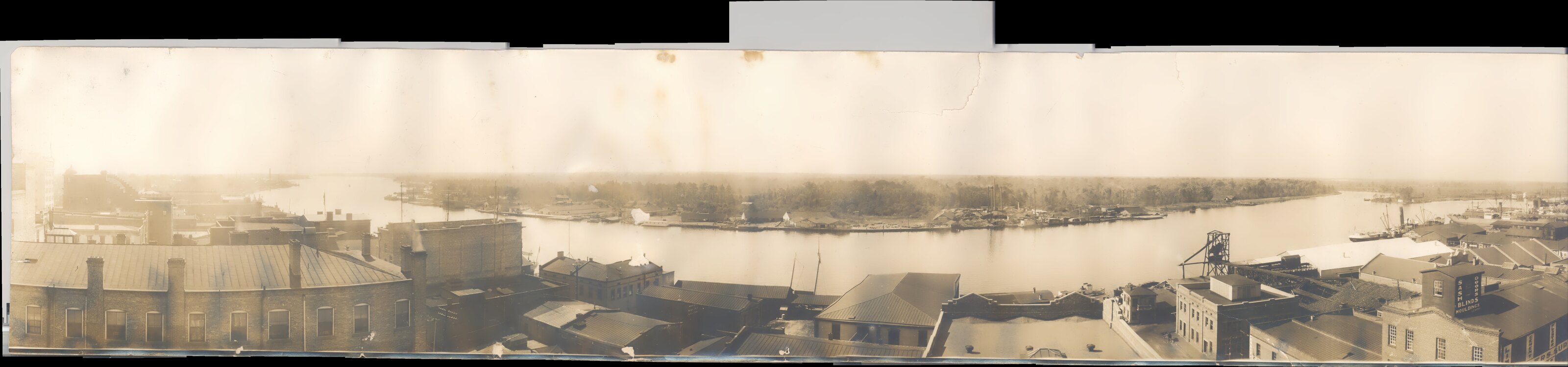
Eagles Island waterfront panorama, circa 1914–15. Taken from the Murchison Building, this view is the principal visual key for identifying the ferry landing, marine railway, naval-stores firms, warehouses, and other shoreline structures. The surviving panorama is held in the North Carolina Room, New Hanover County Public Library; evidence suggests that it was made by the Haines Photo Company of Conneaut, Ohio. Courtesy of New Hanover County Public Library.
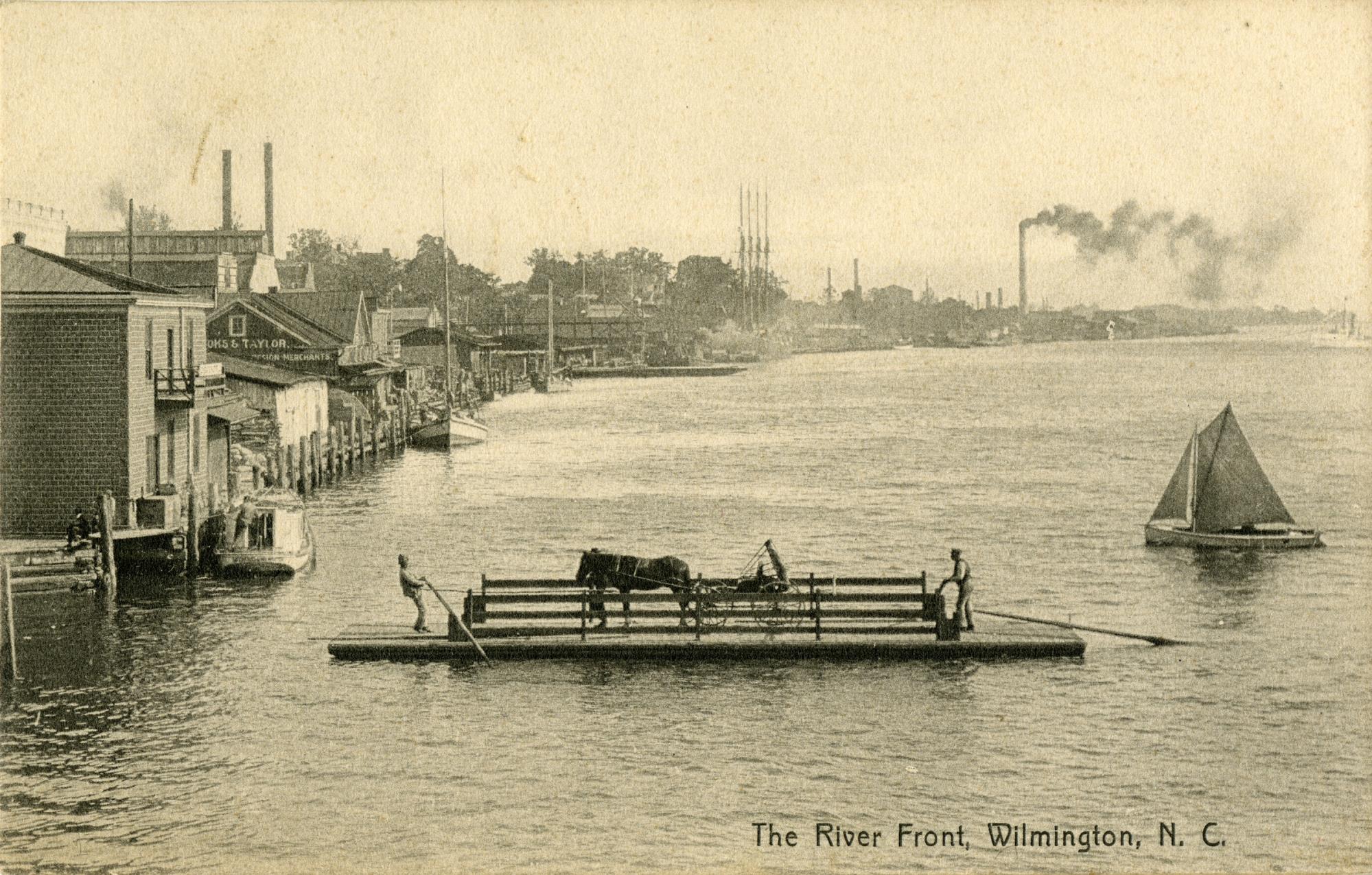
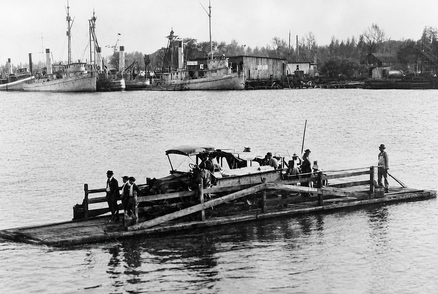
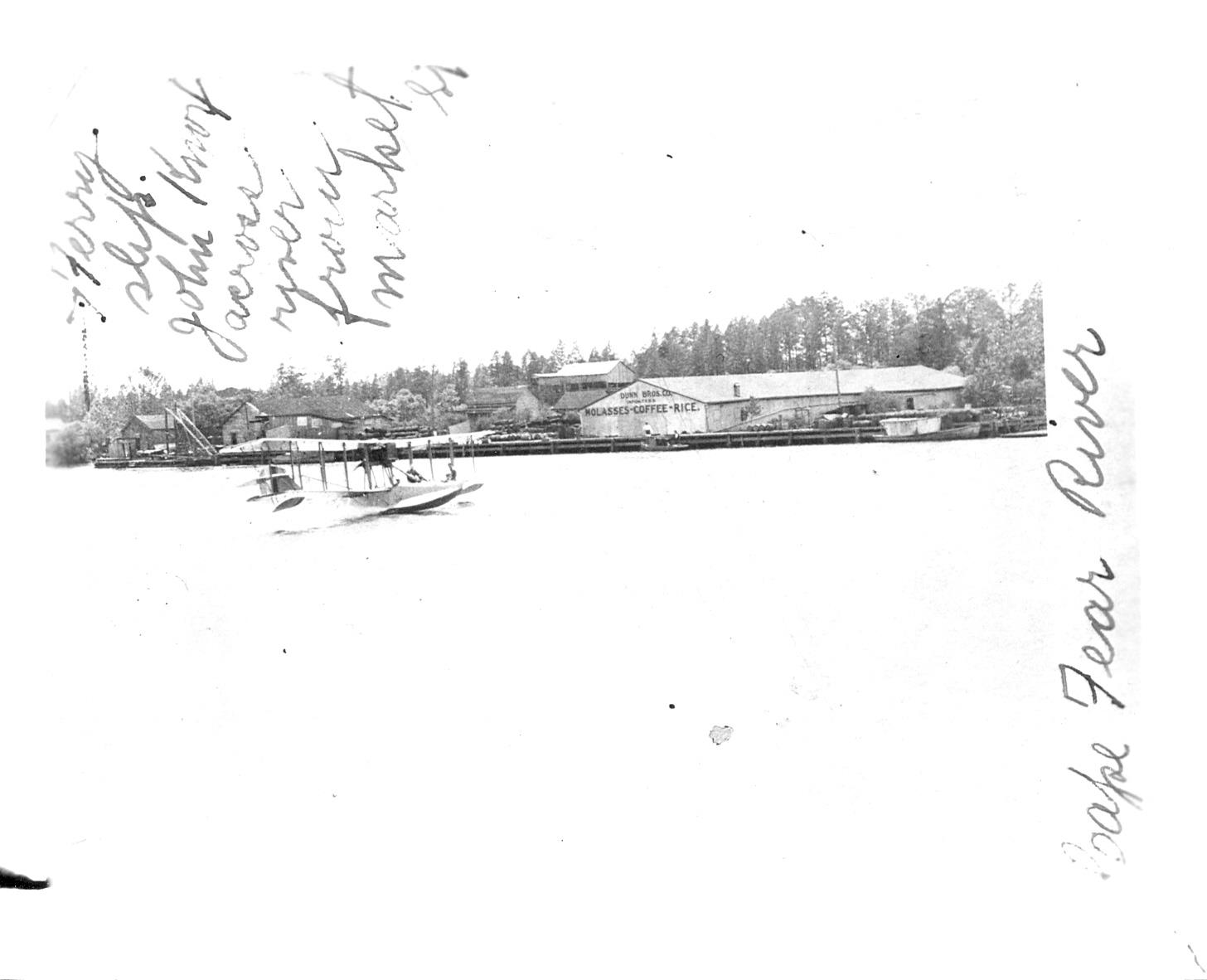
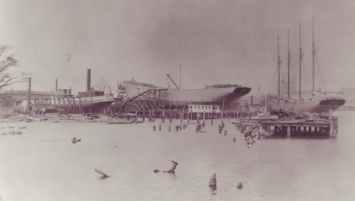
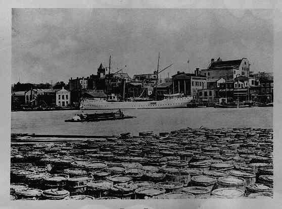
Market Street ferry, March 1, 1912. Veteran ferryman William Jones stands near the stern of the flat, which carried passengers and goods between Wilmington and the Eagles Island causeway. Photograph by Louis T. Moore. Courtesy of the Louis T. Moore Collection, New Hanover County Public Library.Automobile ferry at Eagles Island, early twentieth century. Passengers and an automobile cross the Cape Fear River on a ferry flat. Workboats, wharves, and the commercial waterfront line Eagles Island in the background. Courtesy of the Cape Fear Museum of History and Science, New Hanover County.Seaplane on the Cape Fear River, November 1918. The Dunn Bros. importers’ warehouse—painted with the words “Molasses–Coffee–Rice”—stands on the Eagles Island waterfront behind the aircraft. The smaller C. H. Dock turpentine distillery was immediately beside and behind the warehouse. Courtesy of the Cape Fear Museum of History and Science, New Hanover County.Hoppauge and Commack under construction, 1916–17. The four-masted schooners were built at the Wilmington Marine Railway on Eagles Island. Courtesy of the North Carolina Department of Natural and Cultural Resources, Underwater Archaeology Branch; reproduced in Seeb, fig. 5.5, and Minford, fig. 3-6.Ferry John Knox, in service 1920–35. Built at Morehead City in 1919, the passenger-and-vehicle ferry served the Market Street crossing until February 6, 1935, before being abandoned near the former landing; its remains became archaeological site 0016CFR. Courtesy of New Hanover County Public Library.Naval stores on Eagles Island, late nineteenth century. Barrels crowd the foreground wharf; Market Street and its ferry are visible across the Cape Fear River. The two thesis captions differ on date: Minford identifies the scene as before 1892, while Seeb gives 1900. Courtesy of the Dr. Robert M. Fales Collection, New Hanover County Public Library; reproduced in Minford, fig. 3-1, and Seeb, fig. 5.1.
Cape Fear Museum acknowledgement. The automobile-ferry and November 1918 seaplane photographs above are reproduced from the collection of the Cape Fear Museum of History and Science, New Hanover County. The Museum’s online catalog also provided important evidence for identifying Eagles Island’s ferry landing, naval-stores operations, wharves, and working waterfront. All other photographs are credited individually to their respective holding institutions.
Interactive map
A documented heritage map
This rebuilt map includes only locations that can be tied to a published site plan, historical alignment, documented landscape area, or confirmed modern reference point. Click a marker to see its location basis and sources.
The passenger-and-automobile ferry sank in June 1937 near the former Market Street ferry and causeway landing. North Carolina archaeologists recorded its remains as site 0016CFR, and it is now mapped separately from the southern wreck sequence.
A ferry, a gunboat, and a classroom discovery
Waccamaw / USS Commodore Hull
Built as a ferry in New York in 1860, the vessel served in the Union Navy as USS Commodore Hull before returning to civilian work as Waccamaw. After operating between Wilmington and Southport, it was abandoned and burned along the Eagles Island shoreline. North Carolina archaeologists recorded the remains as site 0001CFR.
In 1991, a class of Pender County eighth graders participated in the investigation under the direction of archaeologists Mark U. Wilde-Ramsing and Richard Triebe. Through fieldwork and historical research, the students helped connect the surviving timbers and machinery with the vessel’s earlier identities. Their work led to the identification of the wreck as Waccamaw—reuniting an overlooked site with a history that encompassed local ferry service, the Civil War, and transportation on the Cape Fear River.
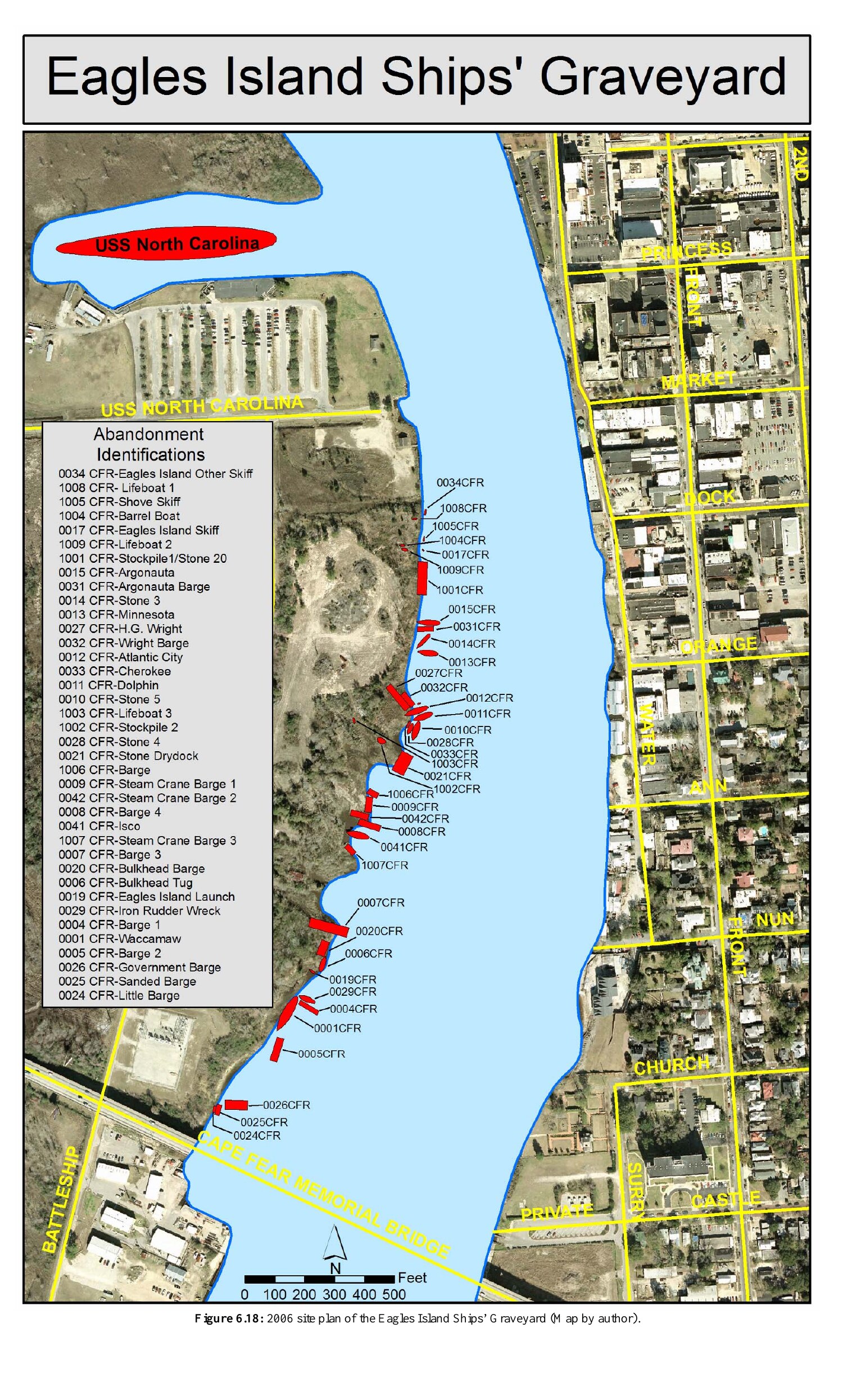
Compare the map with Seeb’s 2006 archaeological site plan2006 site plan of the Eagles Island Ships’ Graveyard. Figure 6.18 in Sami Kay Seeb, Cape Fear’s Forgotten Fleet (M.A. thesis, East Carolina University, 2007). The plan is the principal geographic source for the rebuilt maritime-archaeology layer. Click to enlarge.
1730s – 2026
A timeline of industrial usage
Filter by theme to trace one thread at a time — the railroad's rise and burning, the naval-stores boom and bust, or the slow accumulation of the ships' graveyard.
Goods & trade
What moved through the island
Eagles Island's economy was never a single industry. Its warehouses held the largest guano store in North Carolina, its naval-stores row processed the tar, pitch, and turpentine that once made the state the nation's dominant supplier, and its general merchants sold everything from glue and molasses to cotton gins. Cotton moved by rail to the compress warehouses; ships rotted quietly in the shallows once their working lives ended.
"Warehouses, distilleries, railroad shops and sheds, naval stores and other property" — a 1871 petition for a fire engine, describing the density of industry already crowding the island's shore.
Cited via East Carolina Digital Collections research memoranda
The naval-stores trade tells its own story of extraction and decline: North Carolina supplied 96.7% of the nation's naval stores in 1870, a share that had collapsed to roughly 21% by 1890 as the longleaf pine forests that fed it were exhausted. By 1913, the industry had consolidated enough to draw a federal antitrust suit against the American Naval Stores Company — organized from two firms that had operated directly on this shoreline.
Methodology & sources
Built from primary documents, not memory
Every site and date above is drawn from the sources below. Historical coordinates are schematic reconstructions, not survey data — see the note at the end of this section.
Theses & Society Publications
Sami Kay Seeb, "Cape Fear's Forgotten Fleet: The Eagles Island Ships' Graveyard, Wilmington, North Carolina," M.A. thesis, East Carolina University, March 2007, directed by Dr. Nathan Richards. Read the thesis (PDF)
Robert J. Minford, "For the Love of Profit: Examining Traditional Capitalism on Eagles Island, North Carolina," M.A. thesis, East Carolina University, April 2012, directed by Dr. Nathan Richards. Read the thesis (PDF)
Mark U. Wilde-Ramsing and Joni Thomas “Osku” Backstrom, “Locating and Mapping Archaeological Rice Cultivation Artifacts Associated with the Gullah Geechee Tradition Using Visual Observations and Side Scan Sonar,”Journal of Maritime Archaeology 19 (2024). View the study record
UNCW, “Excavating Evidence of Early Agricultural Engineering,” February 2024. Read the article
T. Addison Richards, “The Rice Lands of the South,”Harper’s Monthly Magazine 19 (1859), pp. 721–738. “Rice Harvesting, U.S. South, 1859” reproduced courtesy of SlaveryImages.org, SI-OB-371; source copy in University of Virginia Library Special Collections.
"Industries of a Feather" (Part One), Historical Society of the Lower Cape Fear Bulletin, 2012. View bulletin (PDF)
Archival Maps & Collections
Jonathan Price and John Strother, “A map of Cape Fear River and its vicinity from the Frying Pan Shoals to Wilmington,” engraved by William Barker, 1798. State Archives of North Carolina; presented by North Carolina Maps.
1889 Sanborn Fire Insurance Map, Sheet 14, "Eagle Island, Brunswick Co., N.C." Library of Congress
East Carolina Digital Collections, items on Champion Compress & Warehouse Co. Item 17078 · Item 17087
NC Underwater Archaeology Branch, Wilmington Historic District Addendum site survey (1983, updated 2006). Read the survey (PDF)
David Shriver Soliday, “Aerial photograph taken over Eagles Island, NC,” 2012. Smithsonian National Museum of African American History and Culture, Gift of David Shriver Soliday, object 2014.216.131.
Dr. Robert M. Fales Collection and Louis T. Moore Collection, New Hanover County Public Library; archival photographs cited individually above.